In which we cross borders to see the stories, some fictive, that maps tell
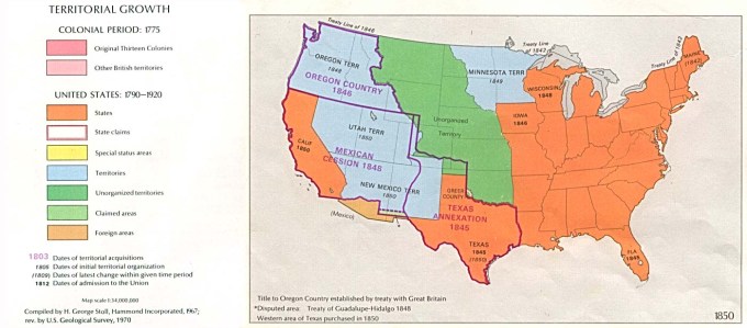
So, kids, here’s a map of the United States in 1840. What do you see?
—Well, it’s colorful.
It is, Kylie. But what do those colors indicate?
—Well, there are different chunks with different colors. The territories like Iowa are in green. And then there’s the Republic of Texas in orange. And then there's stuff in blue; I don't know whose territory that is. The border of Texas seems weird.
So what does that tell you?
—I guess that some stuff hadn’t been worked out yet.
—Montana also looks weird. I know because I went there last summer and looked at maps a lot.
Well, of course, Montana doesn’t really exist yet, Ethan; some of it is unorganized, and some is part of the Oregon territory. But who actually lives there?
—Indians?
Yes. Nez Pearce. Maybe some Blackfoot and Crow. Hard to say with any precision.
—So why aren’t they on the map?
A fair question, Sadie. The United States claimed eastern Montana by virtue of the Louisiana Purchase from France. Native Americans weren’t consulted. Americans made the maps; Indians either didn’t know, didn’t care, or—this was eventually decisive—didn’t have the power to resist. The Oregon territory was claimed by both the United States and Great Britain, but was so remote and unsettled—mostly fur traders out there—that it didn’t seem worth resolving or fighting over that hard. But there are signs this was changing. By the mid-1840s, negotiations, and acrimony, were intensifying. There was even talk of war.
—So what happened?
Eventually that would get worked out. The Oregon territory, which stretched well into Canada, would essentially be split in half. You can see that the line separating the United States and Canada is a pretty straight curve from the Great Lakes to the West Coast.
—It’s kinda cool to see the map snap into place.
Yeah, it is. But in a way it’s a problem.
—Why is that?
Because it makes the contours the nation ultimately assumed seem more natural than they really are. Vancouver could have easily been a part of the United States as not. The border with Mexico could have been a lot different than it turned out. You can see that the frontiers of Maine were also unclear; they got worked out in a treaty with Britain in 1842.
—OK, but why is any of this a problem?
Well, Emily, maybe it’s less a problem than a question.
—What’s the question?
Well, I guess the question is how the map will fall apart.
—Fall apart? Why are you asking that? And why are you asking that in a history class?
That’s a fair question as a reply to my question. I guess my answer is that asking it helps us realize that there’s nothing especially “natural” about the borders of the United States. I say so not only because, as we’ve been discussing, those borders could easily have been drawn another way, but also because—to bring up something we haven’t really discussed—there’s nothing especially cohesive about the series of ecosystems that make up the United States. We’ve got the eastern woodlands on the North Atlantic seaboard. And the prairies of the Midwest. Semi-tropics in the South. Mountains in the west. For hundreds, even thousands, of years, these environmental differences have hosted, and fostered, different cultures. In an important sense, they still do.
—But they don’t matter as much as they used to.
They don’t, Adam?
—No. I can watch ESPN in Montana or in Maine. I can get Doritos in either.
Hey. That’s a good point. We live in a national society that in some respects really has conquered geography. But let me ask you this: do the people who live in Texas tend to vote the same way as people in Oregon?
—A lot of them do.
That’s true: there are Republicans in Oregon and Democrats in Texas. But they’re decided minorities. Back in the 1970s, we used to have a national speed limit of 55 miles per hour because of an oil shortage. People hated it, of course. But some people hated it more than others, for good reason. Driving 55 miles per hour on an otherwise carless road in North Dakota makes a whole lot less sense than doing it on a crowded interstate in New Jersey. To a great extent, that’s because the landscapes are different. Different landscapes create different priorities and different values. Huge tracts of empty land in Wyoming are owned by the U.S. government. Comparatively speaking, there are no huge tracts of empty land in Connecticut, because most of it is easily habitable, unlike the mountains and deserts of the West. These realities, in turn, shape politics: residents of Wyoming tend to see the government as having far too much control over their lives, while many residents of Connecticut wish the government would do more than it does. That’s been true for a long time.
—I still don’t get what this has to do with the future.
What I’m saying, Em, is that there’s no intrinsic reason the United States will continue to exist from sea to shining sea. Given the difference in populations, resources, and position relative to large bodies of water, New England might someday break off from the Gulf states. For that matter, Northern California and Southern California are could easily become separate entities. The other factor here is demographic: the people who live in these places have and will migrate over borders that are ecologically meaningless, especially as coastlines and the routes of rivers get reshaped by climate change.
—Fine. That’s the future. And the past? What does any of this have to do with the class we’re taking right now?
History is a matter of contingency: things that happen in a certain way at a certain time because of certain things human beings do. When you look at the way human beings always act across time and place, well, that’s biology or anthropology. When you’re looking at the logic of ideas that transcend time and place, that’s philosophy. But history is about the interaction of broad impersonal processes and specific decisions people make. There are different factors that shaped the way the map turned out, but they weren't inevitable (not all of them, anyway). We ended up with a continental nation, and looking at it now, it seems so natural, even inevitable. But an important sense it was an accident, as in the car crash sense of the term. People made choices thinking they were doing the right thing—or, at any rate the thing they wanted to do—and a lot of people got hurt. That’s how we got the Mexican War.
—Oh. Is that where we’re going next?
It is. Saddle up.
Next: Mexican mess