In which we see that history is really geography
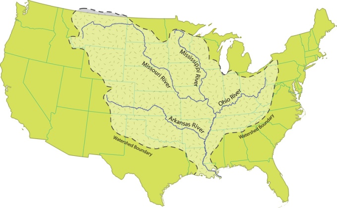
OK kids, so here’s the deal: Until about 200 years ago—which is to say for thousands of years of Native American life, and a couple centuries of Euro American life—rivers were the highways of this continent, the easiest way to move around. Jonquil, I’ve got a map on the Smart Board of North American rivers. Tell me anything that strikes you.
—What strikes me?
Yes. What do you find interesting?
—Well, it looks like there’s a lot of them.
Indeed there are. And these are only the major ones. Any that strike you as particularly interesting?
—The Missouri River looks pretty big. It covers a lot of ground. It’s up there in Montana, maybe Idaho, and it goes all the way down to … duh. Missouri.
It’s hard to see its origin amid the cluster of other rivers, like the Illinois and the Wabash. The Missouri River is big. When Lewis and Clark undertook their big mission to explore the Louisiana Purchase in 1806, they took a team of forty travelers and traced the path of the Missouri. Anything else that strikes you?
—Well, there are a lot of big ones. The Platte River, the Arkansas River, the Red River, the Brazos River. I hadn’t really heard of them.
—There’s the Rio Grande down in Texas. It seems well-named.
Indeed it does, Ethan. The Rio Grande is also notably wide in some places. It forms the border between Texas and Mexico. Which appears to make sense. But as we’ll see, that border wasn’t necessarily obvious. There were those who thought it should be the Brazos River.
—That’s a big difference in terms of how big Texas turned out.
—One of the things that really surprises me is that the rivers you hear a lot about, like the Hudson and the Potomac, don’t seem like much of a big deal. They seem really small and short.
Yeah, but remember, Em, that those rivers are along the Atlantic. New York and Washington are coastal cities.
—Is Washington really a coastal city? I’ve been there a couple times and don’t remember seeing the ocean.
Well, there’s Chesapeake Bay. Which is an economic as well as an environmental ecosystem. There was some effort in the 19th century to connect the Chesapeake with the Ohio River. You can see that the Ohio is pretty significant. It empties into the Mississippi. Look more closely: you’ll see a lot of rivers empty into the Mississippi. It’s like the drain of North America. There are no cities on this map, but can any of you tell me which city sits at the mouth of the Mississippi?
—New Orleans?
Good, Jonquil. New Orleans, Louisiana. It stands to reason that a city in that location would be pretty important, right?
—Well, they did call it the Louisiana Purchase, right?
Exactly so. They didn’t call it the New Orleans Purchase, though.
—Yeah, but Louisiana was like a whole region, no? New Orleans was just a single city. It must have been important.
It was important. It is important. We know that among other things, New Orleans is a multi-racial, multilingual entrepôt.
—What’s an entrepôt?
What does it sound like Kylie?
—I take French. “Entre” means between.
Right. Between what?
—Cities? Ports?
Good. New Orleans was, and is, a major international port. Let me ask you something. Is it the biggest?
—You mean now?
Yes. And two hundred years ago? Was there ever a time you know of when it was?
—In the United States, you mean?
Yes. But you can also see that New Orleans occupies a strategic place in the Americas generally.
—Gonna take a wild guess here, Mr. K., and say the answer is no.
Well, aren’t you a lucky one, Kylie.
—Yeah, well, no one’s luckier than me that way, Mr. K. I’ve got a 50% success rate.
I suppose not, Em. New Orleans was never the biggest. But don’t you think it should’ve been? It sits at the end of the basin into which all these rivers run, and it sits roughly in the middle of the continent. Once the United States made the Louisiana Purchase and the nation controlled most of the territory on the continent, shouldn’t it have become the biggest? The terminal of the biggest superhighway in North America? The Mississippi?
—Not necessarily. You’ve been saying all along that England is where all the trade is. Facing the Atlantic is more important than facing the Gulf of Mexico.
That’s a fair point, Adam. And when you look at the cities that at some point were the largest—Boston, Charleston, Baltimore, Philadelphia—they all did face the Atlantic in some form. But the country is changing now. And if people like Thomas Jefferson get their way—and we know that the Jeffersonian crowd is now running the country—don’t you think there should be more effort to develop the interior? I still don’t get why New Orleans isn’t more valuable.
—Maybe it has something to do with slavery?
A good question, Yin. But if anything, slavery is a reason for a port to grow. The international slave trade, which once made cities like Newport (which, you’ll note is in Rhode Island, not a slave state) legally ended in 1808. But the cotton business is huge: England has an insatiable appetite for American cotton, and a lot of it is indeed headed out from New Orleans. And yet even much of that trade will ultimately end up going North. Why? What’s wrong with New Orleans?
—Who says anything is wrong with New Orleans? Look at Chicago. It sits right there on one of the Great Lakes. It’s also in the interior. Why aren’t you talking about that?
Well, now, Adam, it’s funny that you should bring that up. You’re right: Chicago is near water. The Chicago River runs right through the middle of the city and connects it to Lake Michigan. Of course, right now—we’re like in the 1810s now—Chicago doesn’t exist. When it is founded, in 1833, it’s a tiny village next to the much bigger town of Galena. Eventually, Chicago will become important, and its proximity to water will be a big part of the reason why. And I’m going to get to that. But first let me note that we’ve been having a little argument here. I keep telling you that these interior cities have great potential, and you keep telling me that the Atlantic seaboard is more important. Fine: I’ll concede that point. But let me ask you this: Wouldn’t it be great if there was a port city that could do both: connect the Atlantic and the interior? Wouldn’t that be cool?
—Is there a river that does that?
No.
—So then why are you asking?
Why do you think?
—I have no idea.
But you’re curious, right?
—I guess.
Good.
Next: New York ditch